
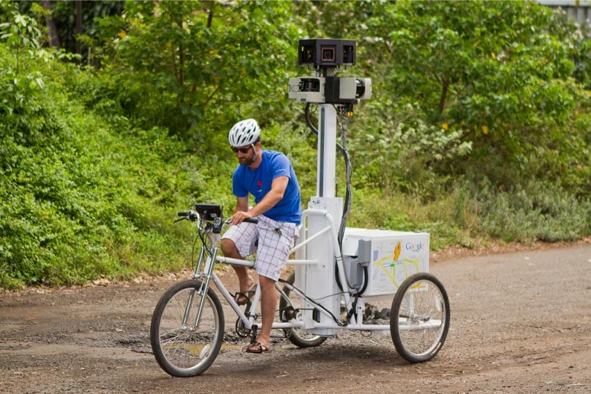
Beginning with U. Hawai‘i at Mānoa, the Google Street View trike – a 250-pound, nine-foot, human-powered machine – has been mapping Hawai‘i’s colleges and state parks.
Google Street View allows users to view images that Street View trikes, cars and snowmobiles capture of streets, schools, hikes, zoos and anything else that Google Maps users want to see on the site.
“They are doing all of the state and city parks, they even did the Honolulu Zoo. … It’s really just trying to get them everywhere that would be good for people to navigate,” said Colin Macdonald, an instructor at UH who Google contacted about mapping the campus.
The Street View team in Hawai‘i has already finished mapping the UH campus, including the Lyon Arboretum, the aquarium in Waikīkī, and the athletic complex.
“We tried to get it to be as comprehensive of the far corners of the campus as we could. At one point we were talking about having them go into Stan Sheriff [Center] arena because there is a ground-level entrance, but the concern was the second they got in there they would lose all of their GPS, and therefore it’s really tough to know where it is,” said Macdonald.
The Google Trike has eight cameras, GPS and lasers, which make it easier to accurately place the images. The pictures are put together in a 360-degree view, blending together the overlapping elements that are created between the eight cameras. This process, as well as the steps that Google takes to protect people’s privacy, means that it takes a while before the images are ready to be uploaded to Google Maps.
“One of the concerns that we had with this was privacy, because one of the things that Google has been knocked for – rightly and perhaps not rightly – over time has been privacy issues,” said Macdonald. “While they were doing our Street View … if they saw someone’s face, the software automatically blurs out the person’s face or a license plate on a car. And finally they said that if there were things that we did not want to get mapped then what Google will do is to blur it out for you. So it was up to our discretion to say that we did not want people to see some things and they would blur it out for us.”
This mapping can aid students in navigating the campus.
“If you wanted to say ‘meet me in front of the Campus Center’ or ‘meet me in front of Student Services’ a lot of people have no idea how to get there. … Even for people who have been on campus a lot, trying to find something is difficult,” said Macdonald.
The Street View trike is scheduled to leave O‘ahu some time in July and either head over to Maui or the Big Island and finish in Kaua‘i. They hope to map Mauna Kea and the observatories on Kīlauea.
“With Street View, you get the view that you would like to get. It’s a wonderful service for the campus just internally, [and] it’s also a wonderful service in being able to reach an audience that literally reaches around the world – and it costs us nothing,” said Macdonald.